 |
 |
|
|
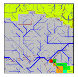
| Station Name (GRDC ID): | Kamativi G/w (1491200) | Basin Name: | Zambezi |
|---|---|---|---|
| River Name: | Gwaai | Next Downstream Station: | None |
| GRDC Country Code: | ZW | Distance to Next Downstream Station: | N.A. |
| Start Year [Month]: | 1955 [10] | Upstream Station(s): | Dahlia Control Section (1491210) |
| End Year [Month]: | 1984 [2] | ||
| Mean Discharge: | 23 m3/s | ||
| Minimum Discharge: | 0 m3/s | ||
| Maximum Discharge: | 575 m3/s | Length of Upstream Mainstem: | 341 km |
| Mean Interstation Discharge: | 16 m3/s | Distance to Basin Outlet: | 1383 km |
| GRDC Catchment Area: | 38600 km2 | STN Catchment Area: | 37973 km2 |
| GRDC Interstation Area: | 17600 km2 | STN Interstation Area: | 20419 km2 |
| GRDC Station Runoff: | 19 mm/yr | STN Station Runoff: | 19 mm/yr |
| GRDC Interstation Runoff: | 29 mm/yr | STN Interstation Runoff: | 25 mm/yr |
| Station Field Descriptions | Basin Field Descriptions | ||
| Download | |
|---|---|
| Site Descriptor Information | Station Time Series Data |
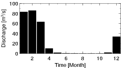
| Hydrograph | Station Data | ||||||||||||||||||||||||||||||||||||||||||||||||||||||||
|---|---|---|---|---|---|---|---|---|---|---|---|---|---|---|---|---|---|---|---|---|---|---|---|---|---|---|---|---|---|---|---|---|---|---|---|---|---|---|---|---|---|---|---|---|---|---|---|---|---|---|---|---|---|---|---|---|---|
|
| ||||||||||||||||||||||||||||||||||||||||||||||||||||||||