 |
 |
|
|
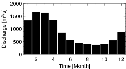
| Station Name (GRDC ID): | Santo Antonio do Leverger (3649619) | Basin Name: | Tocantins |
|---|---|---|---|
| River Name: | Rio Das Mortes | Next Downstream Station: | Conceicao do Araguaia (3649416) |
| GRDC Country Code: | BZ | Distance to Next Downstream Station: | 512 km |
| Start Year [Month]: | 1969 [10] | Upstream Station(s): | Toriqueje (3649614) |
| End Year [Month]: | 1986 [12] | ||
| Mean Discharge: | 868 m3/s | ||
| Minimum Discharge: | 218 m3/s | ||
| Maximum Discharge: | 3084 m3/s | Length of Upstream Mainstem: | 689 km |
| Mean Interstation Discharge: | 523 m3/s | Distance to Basin Outlet: | 1547 km |
| GRDC Catchment Area: | 55346 km2 | STN Catchment Area: | 56853 km2 |
| GRDC Interstation Area: | 37496 km2 | STN Interstation Area: | 38966 km2 |
| GRDC Station Runoff: | 494 mm/yr | STN Station Runoff: | 481 mm/yr |
| GRDC Interstation Runoff: | 440 mm/yr | STN Interstation Runoff: | 423 mm/yr |
| Station Field Descriptions | Basin Field Descriptions | ||
| Download | |
|---|---|
| Site Descriptor Information | Station Time Series Data |
| Hydrograph | Station Data | ||||||||||||||||||||||||||||||||||||||||||||||||||||||||
|---|---|---|---|---|---|---|---|---|---|---|---|---|---|---|---|---|---|---|---|---|---|---|---|---|---|---|---|---|---|---|---|---|---|---|---|---|---|---|---|---|---|---|---|---|---|---|---|---|---|---|---|---|---|---|---|---|---|
|
| ||||||||||||||||||||||||||||||||||||||||||||||||||||||||