 |
 |
|
|
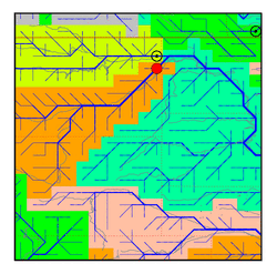
| Station Name (GRDC ID): | Sidney, Mont. (4120950) | Basin Name: | Mississippi |
|---|---|---|---|
| River Name: | Yellowstone | Next Downstream Station: | Yankton, S.D. (4121800) |
| GRDC Country Code: | US | Distance to Next Downstream Station: | 982 km |
| Start Year [Month]: | 1965 [1] | Upstream Station(s): | None |
| End Year [Month]: | 1984 [12] | ||
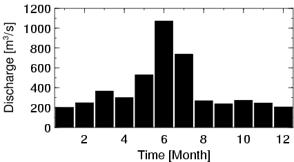
| Mean Discharge: | 391 m3/s | ||
| Minimum Discharge: | 104 m3/s | ||
| Maximum Discharge: | 1601 m3/s | Length of Upstream Mainstem: | 865 km |
| Mean Interstation Discharge: | 391 m3/s | Distance to Basin Outlet: | 3130 km |
| GRDC Catchment Area: | 178977 km2 | STN Catchment Area: | 173162 km2 |
| GRDC Interstation Area: | 178977 km2 | STN Interstation Area: | 173162 km2 |
| GRDC Station Runoff: | 69 mm/yr | STN Station Runoff: | 71 mm/yr |
| GRDC Interstation Runoff: | 69 mm/yr | STN Interstation Runoff: | 71 mm/yr |
| Station Field Descriptions | Basin Field Descriptions | ||
| Download | |
|---|---|
| Site Descriptor Information | Station Time Series Data |
| Hydrograph | Station Data | ||||||||||||||||||||||||||||||||||||||||||||||||||||||||
|---|---|---|---|---|---|---|---|---|---|---|---|---|---|---|---|---|---|---|---|---|---|---|---|---|---|---|---|---|---|---|---|---|---|---|---|---|---|---|---|---|---|---|---|---|---|---|---|---|---|---|---|---|---|---|---|---|---|
|
| ||||||||||||||||||||||||||||||||||||||||||||||||||||||||