 |
 |
|
|
| Station Name (GRDC ID): | Louisville, Nebr. (4122600) | Basin Name: | Mississippi |
|---|---|---|---|
| River Name: | Platte | Next Downstream Station: | Nebraska City, Nebr. (4122650) |
| GRDC Country Code: | US | Distance to Next Downstream Station: | 70 km |
| Start Year [Month]: | 1973 [1] | Upstream Station(s): | None |
| End Year [Month]: | 1984 [9] | ||
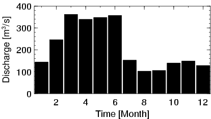
| Mean Discharge: | 215 m3/s | ||
| Minimum Discharge: | 18 m3/s | ||
| Maximum Discharge: | 1116 m3/s | Length of Upstream Mainstem: | 1315 km |
| Mean Interstation Discharge: | 215 m3/s | Distance to Basin Outlet: | 1887 km |
| GRDC Catchment Area: | 222222 km2 | STN Catchment Area: | 215978 km2 |
| GRDC Interstation Area: | 222222 km2 | STN Interstation Area: | 215978 km2 |
| GRDC Station Runoff: | 30 mm/yr | STN Station Runoff: | 31 mm/yr |
| GRDC Interstation Runoff: | 30 mm/yr | STN Interstation Runoff: | 31 mm/yr |
| Station Field Descriptions | Basin Field Descriptions | ||
| Download | |
|---|---|
| Site Descriptor Information | Station Time Series Data |
| Hydrograph | Station Data | ||||||||||||||||||||||||||||||||||||||||||||||||||||||||
|---|---|---|---|---|---|---|---|---|---|---|---|---|---|---|---|---|---|---|---|---|---|---|---|---|---|---|---|---|---|---|---|---|---|---|---|---|---|---|---|---|---|---|---|---|---|---|---|---|---|---|---|---|---|---|---|---|---|
|
| ||||||||||||||||||||||||||||||||||||||||||||||||||||||||