 |
 |
|
|
| Station Name (GRDC ID): | Lees Ferry, Ariz. (4152450) | Basin Name: | Colorado (Ari) |
|---|---|---|---|
| River Name: | Colorado | Next Downstream Station: | Yuma, Ariz. (4152100) |
| GRDC Country Code: | US | Distance to Next Downstream Station: | 745 km |
| Start Year [Month]: | 1911 [1] | Upstream Station(s): | Green River, Utah (4152550) |
| End Year [Month]: | 1984 [12] | ||
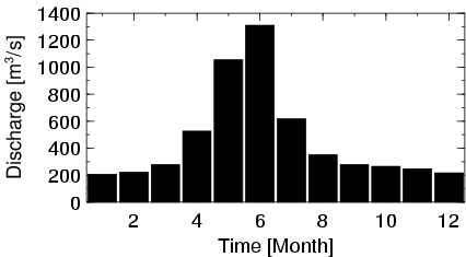
| Mean Discharge: | 464 m3/s | ||
| Minimum Discharge: | 27 m3/s | ||
| Maximum Discharge: | 3783 m3/s | Length of Upstream Mainstem: | 844 km |
| Mean Interstation Discharge: | 287 m3/s | Distance to Basin Outlet: | 1019 km |
| GRDC Catchment Area: | 289562 km2 | STN Catchment Area: | 283543 km2 |
| GRDC Interstation Area: | 184408 km2 | STN Interstation Area: | 180698 km2 |
| GRDC Station Runoff: | 51 mm/yr | STN Station Runoff: | 52 mm/yr |
| GRDC Interstation Runoff: | 49 mm/yr | STN Interstation Runoff: | 50 mm/yr |
| Station Field Descriptions | Basin Field Descriptions | ||
| Download | |
|---|---|
| Site Descriptor Information | Station Time Series Data |
| Hydrograph | Station Data | ||||||||||||||||||||||||||||||||||||||||||||||||||||||||
|---|---|---|---|---|---|---|---|---|---|---|---|---|---|---|---|---|---|---|---|---|---|---|---|---|---|---|---|---|---|---|---|---|---|---|---|---|---|---|---|---|---|---|---|---|---|---|---|---|---|---|---|---|---|---|---|---|---|
|
| ||||||||||||||||||||||||||||||||||||||||||||||||||||||||