 |
 |
|
|
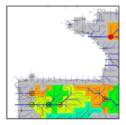
| Station Name (GRDC ID): | Montjean (6123100) | Basin Name: | Loire |
|---|---|---|---|
| River Name: | Loire | Next Downstream Station: | None |
| GRDC Country Code: | FR | Distance to Next Downstream Station: | N.A. |
| Start Year [Month]: | 1863 [1] | Upstream Station(s): | Blois (6123300) |
| End Year [Month]: | 1979 [12] | ||
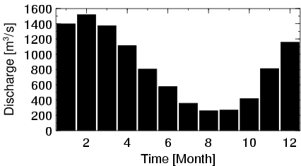
| Mean Discharge: | 838 m3/s | ||
| Minimum Discharge: | 60 m3/s | ||
| Maximum Discharge: | 4200 m3/s | Length of Upstream Mainstem: | 725 km |
| Mean Interstation Discharge: | 474 m3/s | Distance to Basin Outlet: | 151 km |
| GRDC Catchment Area: | 110000 km2 | STN Catchment Area: | 109908 km2 |
| GRDC Interstation Area: | 71760 km2 | STN Interstation Area: | 69278 km2 |
| GRDC Station Runoff: | 240 mm/yr | STN Station Runoff: | 240 mm/yr |
| GRDC Interstation Runoff: | 208 mm/yr | STN Interstation Runoff: | 216 mm/yr |
| Station Field Descriptions | Basin Field Descriptions | ||
| Download | |
|---|---|
| Site Descriptor Information | Station Time Series Data |
| Hydrograph | Station Data | ||||||||||||||||||||||||||||||||||||||||||||||||||||||||
|---|---|---|---|---|---|---|---|---|---|---|---|---|---|---|---|---|---|---|---|---|---|---|---|---|---|---|---|---|---|---|---|---|---|---|---|---|---|---|---|---|---|---|---|---|---|---|---|---|---|---|---|---|---|---|---|---|---|
|
| ||||||||||||||||||||||||||||||||||||||||||||||||||||||||