 |
 |
|
|
| Station Name (GRDC ID): | Untersiggenthal (6935300) | Basin Name: | Rhine |
|---|---|---|---|
| River Name: | Aare | Next Downstream Station: | Basel(St.Alban) (6935050) |
| GRDC Country Code: | SW | Distance to Next Downstream Station: | 75 km |
| Start Year [Month]: | 1961 [1] | Upstream Station(s): | None |
| End Year [Month]: | 1993 [12] | ||
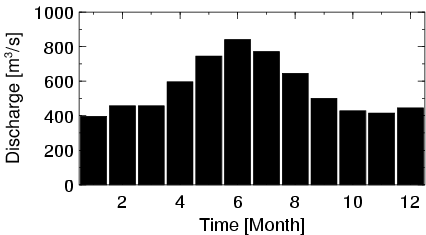
| Mean Discharge: | 558 m3/s | ||
| Minimum Discharge: | 172 m3/s | ||
| Maximum Discharge: | 1342 m3/s | Length of Upstream Mainstem: | 273 km |
| Mean Interstation Discharge: | 558 m3/s | Distance to Basin Outlet: | 782 km |
| GRDC Catchment Area: | 17625 km2 | STN Catchment Area: | 18865 km2 |
| GRDC Interstation Area: | 17625 km2 | STN Interstation Area: | 18865 km2 |
| GRDC Station Runoff: | 999 mm/yr | STN Station Runoff: | 933 mm/yr |
| GRDC Interstation Runoff: | 999 mm/yr | STN Interstation Runoff: | 933 mm/yr |
| Station Field Descriptions | Basin Field Descriptions | ||
| Download | |
|---|---|
| Site Descriptor Information | Station Time Series Data |
| Hydrograph | Station Data | ||||||||||||||||||||||||||||||||||||||||||||||||||||||||
|---|---|---|---|---|---|---|---|---|---|---|---|---|---|---|---|---|---|---|---|---|---|---|---|---|---|---|---|---|---|---|---|---|---|---|---|---|---|---|---|---|---|---|---|---|---|---|---|---|---|---|---|---|---|---|---|---|---|
|
| ||||||||||||||||||||||||||||||||||||||||||||||||||||||||